
Map layers
Map layers are used to make customized layers in the map for specific modules (e.g. Tasks).
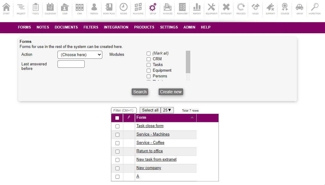
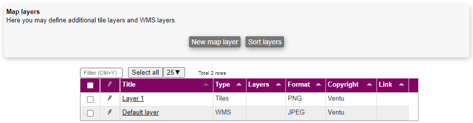
Manage map layers
Accessing map layers is done by accessing the SETTINGS > MAP LAYERS menu.
In the same menu, it's possible to edit and delete the existing map layers.
Creating a map layer
Creating a map layer is done by using the New map layer button.
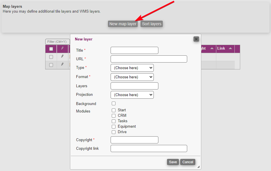
To create a new map layer you need to fill out the following:
Title: Name of the map layer
URL: A URL for the new map layer
Type: Choose one of the following types:
Tiles
WMS
Format: Choose one of the following formats, this is only relevant for WMS maps:
JPEG
PNG
Layers: This is only relevant for WMS maps; the value is passed on to the WMS server to tell it which layers to use
Projection: Choose one of the following projections:
WebMercator
EPGS:25832
Background: This specifies if this is a background layer (eg. satellite photo) or a foreground layer (eg. water pipes or bicycle paths)
Modules: The modules checked here, will have the new map layer available
Copyright: A text for copyright
Copyright link: A link for the copyright
When you are done creating the map layer, you can press Save.
Notice: you should not attempt to mix maps in different projections.
Assign map layer
To assign a map layer, you can do so as explained here.
External sources of maps
Here are some possible sources of maps. Ventu claims no responsibility for the availability/accuracy/usefulness of the maps or of the list below.
Denmark
dataforsyningen.dk has a large number of background maps and layers. You will need to create a (free) login and get token for accessing the maps; insert the token in the URLs instead of MYTOKEN. You can explore the maps on https://sdfikort.dk/spatialmap.
Name | URL | Type | Projection | Layer | Notes |
|---|---|---|---|---|---|
Topografisk kort 1953-1796 | WMS | EPSG:25832 | topo4cm_1953_1976 | Background | |
Ortofoto 1999 | https://api.dataforsyningen.dk/orto_sommer_1999?ignoreillegallayers=TRUE&transparent=TRUE&token=MYTOKEN& | WMS | EPSG:25832 | orto_sommer_1999 | Background |
Skærmkort | WMS | EPSG:25832 | topo_skaermkort | Background | |
Skyggekort | https://api.dataforsyningen.dk/wms/dhm_temp?ignoreillegallayers=TRUE&transparent=TRUE&token=MYTOKEN& | WMS | EPSG:25832 | quickDHM_skyggekort_terraen_overdrevet | Background |
Højdekurver 2.5m | https://api.dataforsyningen.dk/dhm_DAF?ignoreillegallayers=TRUE&transparent=TRUE&token=MYTOKEN& | WMS | EPSG:25832 | dhm_kurve_traditionel | Foreground |
Matrikelkort | https://api.dataforsyningen.dk/wms/MatGaeldendeOgForeloebigWMS_DAF?token=MYTOKEN& | WMS | EPSG:25832 | MatrikelSkel_Gaeldende | Foreground |
Husnumre | https://api.dataforsyningen.dk/forvaltning2?transparent=TRUE&token=MYTOKEN& | WMS | EPSG:25832 | Husnummer | Foreground |
Germany
Name | URL | Type | Projection | Layer | Notes |
|---|---|---|---|---|---|
WEB RASTER | Tiles | Webmercator | Background | ||
Orthophotos | hhttps://sg.geodatenzentrum.de/wms_dop__e01bd0ce-4150-8a75-7e30-e5511caab5c3?TRANSPARENT=true | WMS | Webmercator | rgb | Background |